ARTICLES
Can You Figure It Out? A “Mysterious Route Map” Drawn with Red Lines and Blue Dots. Where Is This? “I’m a Local, So I Knew Right Away”


【#ChallengeForGeographyLovers 467】
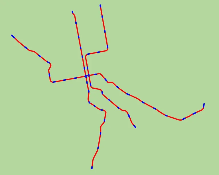
Can you guess where this map is from?
Please try to guess the region in Japan (railway line 🛤) using only the “#RouteMap”. We look forward to your attempts!

Source: @geotofficial's post
As soon as it was posted, people began to speculate based on the slight shapes of the lines and the angles of the branches. There seems to be a central station with three lines. On social media, comments poured in, such as “I’m a local, so I knew right away” and “If you’re a Hokkaido resident, you’ll figure it out pretty quickly.”
Did You Get It? The Correct Answer is the “Sapporo Municipal Subway”
If you have a connection to Sapporo, you might have guessed it. The correct answer was the “Sapporo Municipal Subway”!
【#ChallengeForGeographyLovers 467】
The correct answer for today was the “#SapporoMunicipalSubway”.
This is a subway system operated by the Sapporo City Transportation Bureau in Hokkaido. Its unique system is sometimes called the “#SapporoSystem”. It opened in 1971 and has 3 lines and 46 stations.
We look forward to your future challenges.

Source: @geotofficial's post
The Sapporo Municipal Subway has three lines—the Namboku Line, the Tozai Line, and the Toho Line—and is an essential mode of transportation for Sapporo citizens for commuting and tourism. Its rubber-tired transit system, known as the “Sapporo System,” is a distinctive feature not found in other cities. Were you able to figure it out?
Maybe a Region You Know Will Be Featured? “#ChallengeForGeographyLovers”

The mobility app “TRIMA” by GeoTechnologies is collaborating with Sanrio Characters
The “#ChallengeForGeographyLovers,” updated on the official X account of GeoTechnologies Inc., is a quiz where you guess the region and line from just a route map. People speculate based on slight curves of the lines, branches, and station placements. GeoTechnologies is known for its digital maps for car navigation systems, but recently they have been sharing the fun of geography in various ways, such as through the mobility app “TRIMA” and their original VTuber, “Kaname Hoi.”
GeoTechnologies' official VTuber “Kaname Hoi” performs an original song
In the “#ChallengeForGeographyLovers,” a town or line you know might appear. Be sure to check out the next “challenge”!
X (formerly Twitter): @geotofficial

- 1
- 2