ARTICLES
Latest 2025 Edition: A Must-See for Riders! 17 Spectacular Roads for Touring in Hokkaido


Hokkaido is full of dynamic roads perfect for touring and driving, where you can experience vast nature and magnificent landscapes. Here are our top 17 recommended scenic roads in Hokkaido, perfect for the touring season!
- The Japan Sea Ororon Line: Leading to Cape Soya, Japan's Northernmost Tip
- The White Road on Soya Hills: Enjoy Panoramic Contrasts of Nature
- The Esanuka Line: A Straight Shot Through Pastures to the Horizon
- The Shiretoko Crossing Road: Experience a World Heritage Site
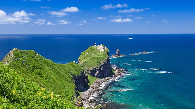
- Notsuke Peninsula: Japan's Largest Sand Spit
- The Milk Road: A Straight Road Through a Peaceful Dairy Farming Region
- The North Pacific Seaside Line: Head to Cape Nosappu Along a Dramatic Coastline
- The Roller Coaster Road: A Straight Road with Intense Ups and Downs
- Mikuni Pass Matsumi Ohashi Bridge: A Sky-High Bridge in a Sea of Trees Beyond a Birch Forest
- Naitai Highland Farm: Overlooking the Tokachi Plain
- Bihoro Pass: A World-Class View
- The Road to Heaven: Be Moved by a Road Stretching to the Far Horizon!
- The Niseko Panorama Line: Enjoy the Four Seasons of Nature's Grandeur
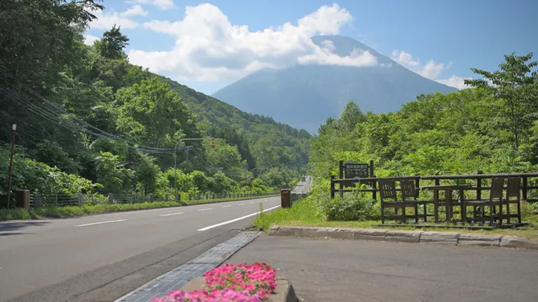
- Aikawa Viewpoint Parking: A 'Yama-ate' Road with a View of Mt. Yotei
- Lake Shikotsu Sky Road: A Stretch of Blue Beyond the Deep Green Forest
- Shakotan Peninsula Blue Line: Tour Scenic Spots Along a Beautiful Coastal Route
- Akan Crossing Road: Experience Magnificent Nature
1. The Japan Sea Ororon Line: Leading to Cape Soya, Japan's Northernmost Tip
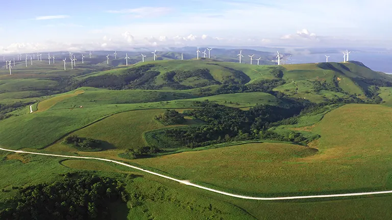
This is the name for the route that runs north-south along the Sea of Japan coast from Otaru City towards Wakkanai. Hokkaido Route 106, which stretches north from Teshio Town, is particularly special. It passes the spectacular row of windmills at the Otonrui Wind Farm and continues as a perfectly straight road through the undeveloped Sarobetsu Plain. On a clear day, you can see Mt. Rishiri (Rishiri Fuji) across the sea. Driving this road to Cape Soya, the northernmost point of Japan, is a popular route for road trips and motorcycle tours. Wakkanai, home to Cape Soya, also features other scenic roads like the Soya Hills and the White Road.
 Japan Sea Ororon Line
■Reference Distance (without using toll roads)
・Tomakomai East Port to Teshio Town: Approx. 287 km
・Teshio Town to Cape Soya (via Route 106): Approx. 93 km
See more details about the "Japan Sea Ororon Line" on Domingo
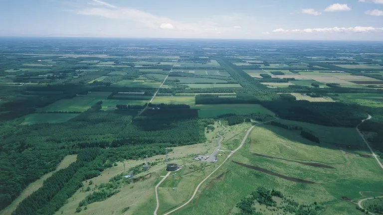
2. The White Road on Soya Hills: Enjoy Panoramic Contrasts of Nature
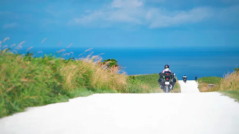
The Soya Hills, spreading out behind Japan's northernmost point of Cape Soya, are a remnant of the Ice Age known as periglacial topography and are registered as a Hokkaido Heritage site. The 'White Road' within these hills is located near the end of a footpath course and is a very popular photo spot. Beyond the panoramic ridgeline, a group of windmills stretches out. The 'White Road,' paved with crushed scallop shells, offers a stunning view with a beautiful contrast between the white path, the blue sky, and the sea.
The White Road
■Reference Distance (without using toll roads)
・Tomakomai East Port to the Soya Hills 'White Road': Approx. 373 km
・Wakkanai City to the Soya Hills 'White Road': Approx. 25 km
See more details about the "White Road" on Domingo
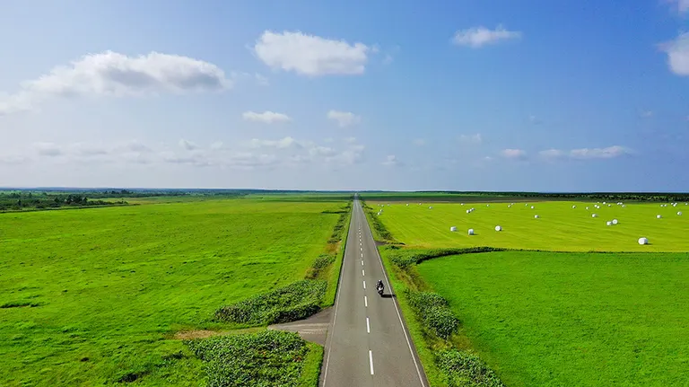
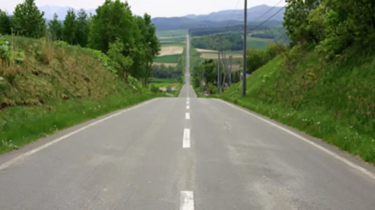
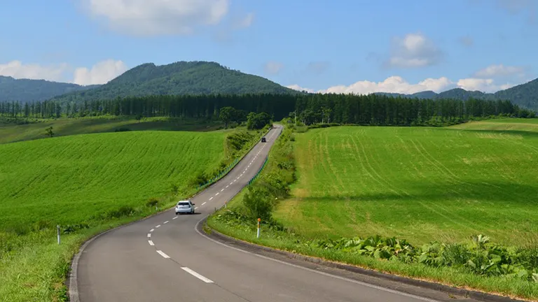
3. The Esanuka Line: A Straight Shot Through Pastures to the Horizon
From the roadside station 'Sarufutsu Park' in Sarufutsu Village, famous for its scallops, head south on National Route 238 for about 18 km and turn onto a village road on the Sea of Okhotsk side. There, you'll find a road that every rider dreams of: a perfectly straight shot through pastureland toward the horizon, with no utility poles, guardrails, or even buildings in sight. For about 16 km, there's nothing but the road you're on, the sky, and the horizon. Be sure to experience the exhilarating feeling of speeding through this open landscape.
Esanuka Line
■Reference Distance (without using toll roads)
・Tomakomai East Port to Esanuka Line: Approx. 363 km
・Cape Soya to Esanuka Line: Approx. 46 km
See more details about the "Esanuka Line" on Domingo
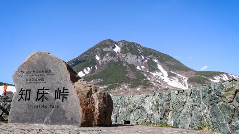
4. The Shiretoko Crossing Road: Experience a World Heritage Site
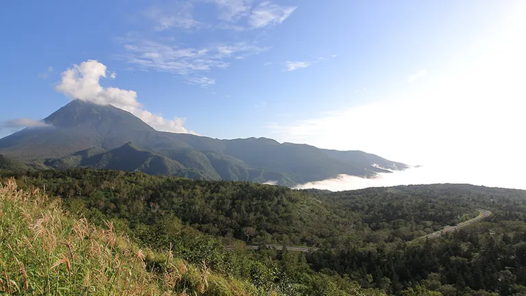
This mountain pass connects Shari Town and Rausu Town in Shiretoko, a World Heritage site. The dynamic view of the vast wilderness from the Shiretoko Pass summit is breathtaking. The Shiretoko Crossing Road is closed for winter from around November to late April each year, so the driving season is short, but it's a must-drive road for anyone wanting to experience the nature of Shiretoko.
Shiretoko Pass
■Reference Distance (without using toll roads)
・Tomakomai East Port to Shiretoko Pass: Approx. 437 km
・Esanuka Line to Shiretoko Pass: Approx. 341 km
See more details about "Shiretoko Pass" on Domingo
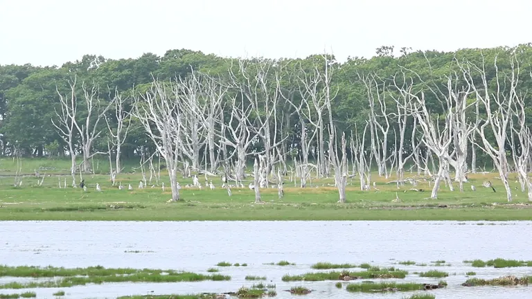
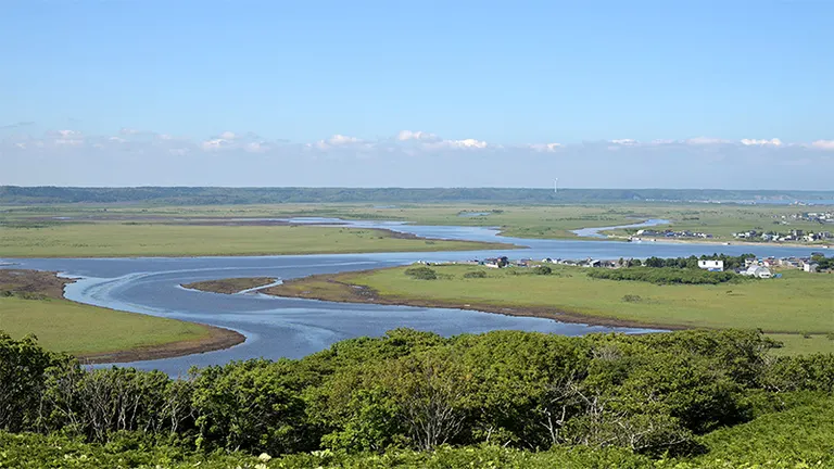
5. Notsuke Peninsula: Japan's Largest Sand Spit
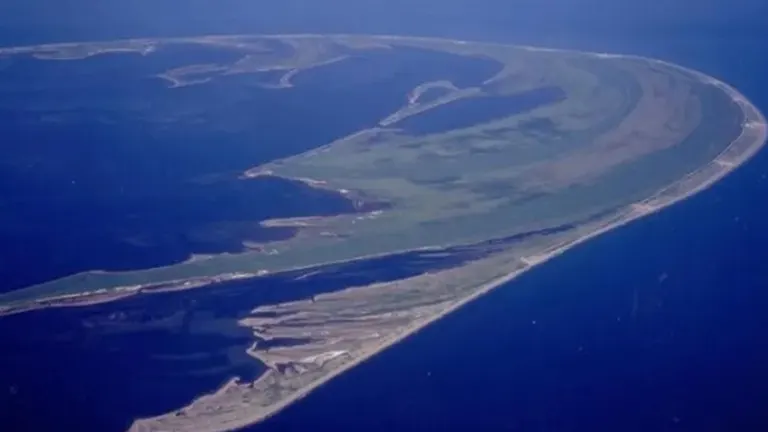
A sand spit is a landform created by the long-term deposition of sand carried by ocean currents, and the Notsuke Peninsula is famous for being the largest one in Japan. A single road, flanked by the sea on both sides, runs from the base of the peninsula to the tip where the nature center is located. The desolate landscapes, such as 'Narawara' with its withered oak trees and 'Todowara' with its withered fir trees, are a sight to behold. In recent years, due to environmental changes and land subsidence, sand is being washed away, narrowing the road. There are concerns that the peninsula itself may disappear, making this an increasingly precious road to experience.
Notsuke Peninsula
■Reference Distance (without using toll roads)
・Tomakomai East Port to Notsuke Peninsula: Approx. 402 km
・Shiretoko Pass to Notsuke Peninsula: Approx. 82 km
See more details about "Notsuke Peninsula" on Domingo
6. The Milk Road: A Straight Road Through a Peaceful Dairy Farming Region
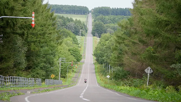
A popular spot for touring riders is the Kaiyodai Observatory, a landmark in Nakashibetsu Town in eastern Hokkaido, offering panoramic views from an altitude of 270 meters. The straight road that cuts through the dairy farming region at its base is called the 'Milk Road.' Named after the milk tankers that drive along this straight path, the road passes through 'grid-like windbreak forests,' a designated Hokkaido Heritage site, offering a peaceful landscape. Autumn is also highly recommended, when the larch trees in the windbreaks turn a beautiful color.
Milk Road
■Reference Distance (without using toll roads)
・Tomakomai East Port to Kaiyodai Observatory: Approx. 363 km
・Notsuke Peninsula to Kaiyodai Observatory: Approx. 47 km
See more details about the "Milk Road (Kaiyodai)" on Domingo
7. The North Pacific Seaside Line: Head to Cape Nosappu Along a Dramatic Coastline
This coastal road stretches for about 321 km from Hiroo Town in Tokachi to Cape Nosappu in Nemuro City. The section from Kushiro Town through Akkeshi and Hamanaka towns towards Nemuro is particularly known as the 'Cape, Flower, and Fog Road,' featuring dramatic cliffs and wetlands. With parking areas scattered along the way, you can take your time to enjoy the scenery. The ever-changing natural views ensure a captivating drive.
North Pacific Seaside Line
■Reference Distance (without using toll roads)
・Tomakomai East Port to Cape Nosappu: Approx. 436 km
・Kushiro Town to Cape Nosappu: Approx. 137 km
See more details about the "North Pacific Seaside Line" on Domingo
8. The Roller Coaster Road: A Straight Road with Intense Ups and Downs
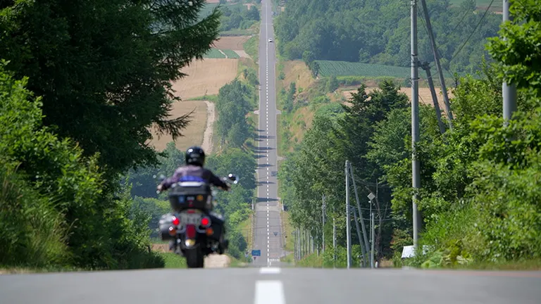
This famous road, selected as one of the 'Eight Views of Kamifurano,' is the nickname for Town Road Nishi 11-sen, which turns off National Route 237 connecting Biei and Kamifurano. The series of rolling hills with their significant elevation changes is truly worthy of the name 'Roller Coaster.' You can enjoy a classic, grand Hokkaido landscape while gazing at the magnificent Tokachi Mountain Range.
Roller Coaster Road
■Reference Distance (without using toll roads)
・Tomakomai East Port to the Roller Coaster Road: Approx. 165 km
・Sapporo City to the Roller Coaster Road: Approx. 137 km
See more details about the "Roller Coaster Road" on Domingo
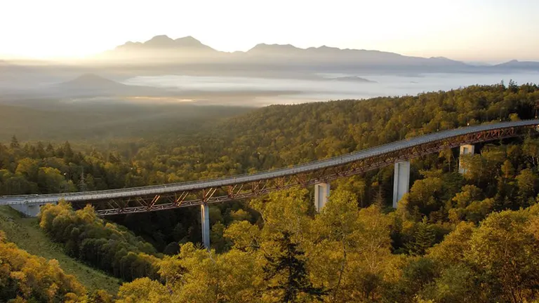
9. Mikuni Pass Matsumi Ohashi Bridge: A Sky-High Bridge in a Sea of Trees Beyond a Birch Forest
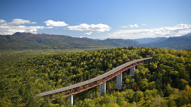
As you travel along National Route 273 from Kamishihoro to Kamikawa, you can see the concrete arch bridges of the former JNR Shihoro Line, as well as the Taushubetsu River Bridge, known as the 'phantom bridge.' After passing the site of the former Mitsumata Station, the terminus of the Shihoro Line, a refreshing avenue of white birch trees leads you into a primeval forest towards Mikuni Pass, the highest national highway pass in Hokkaido. The view from near the summit—a vast sea of trees with the Matsumi Ohashi Bridge standing amidst it—is a breathtaking sight that will leave visitors in awe.
Mikuni Pass Matsumi Ohashi Bridge
■Reference Distance (without using toll roads)
・Tomakomai East Port to Mikuni Pass: Approx. 234 km
・Kamishihoro Town to Mikuni Pass: Approx. 54 km
See more details about the "Mikuni Pass Matsumi Ohashi Bridge" on Domingo
10. Naitai Highland Farm: Overlooking the Tokachi Plain
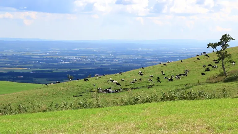
Located about 10 km from the town center of Kamishihoro along Hokkaido Route 806, Naitai Highland Farm is Japan's largest public farm, covering approximately 1,700 hectares (358 times the size of the Tokyo Dome). A rolling road leads from the entrance to the summit, flanked by vast pastures where you can see herds of cattle leisurely grazing—a truly soothing sight. Near the top is the 'Naitai Terrace,' where you can enjoy light meals at a scenic cafe and terrace. From here, you can overlook not only the farm but also the patchwork of fields stretching across the Tokachi Plain.
Naitai Highland Farm
■Reference Distance (without using toll roads)
・Tomakomai East Port to Naitai Highland Farm: Approx. 198 km
・Kamishihoro Town to Naitai Highland Farm: Approx. 10 km
See more details about "Naitai Highland Farm" on Domingo
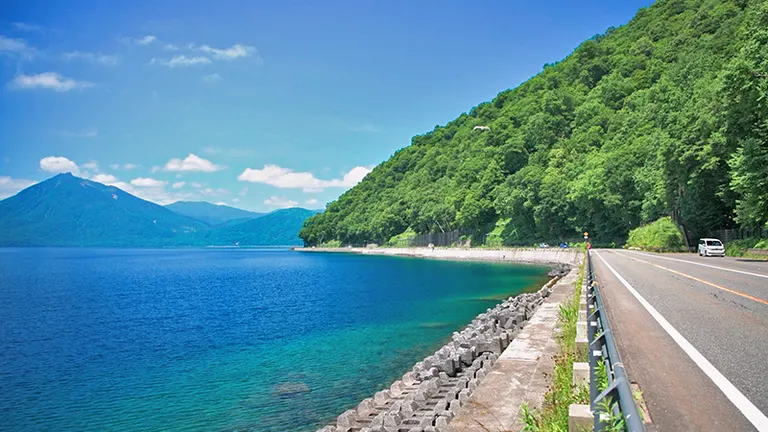
11. Bihoro Pass: A World-Class View
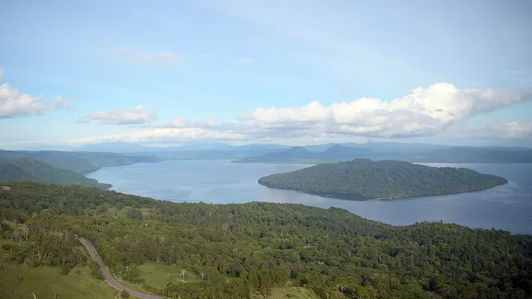
This pass is located on National Route 243 on the border between Bihoro and Teshikaga towns. The view from its observatory is so beautiful that it has been dubbed a 'world-class view.' Not only can you get a panoramic view of Lake Kussharo, Japan's largest caldera lake, but you can also see as far as Mt. Io and the Shiretoko Mountain Range. There is also the Michi-no-Eki (Roadside Station) 'Gurutto Panorama Bihoro Pass,' making it a perfect spot to rest while enjoying the scenery.
Bihoro Pass
■Reference Distance (without using toll roads)
・Tomakomai East Port to Bihoro Pass: Approx. 338 km
・Bihoro Town to Bihoro Pass: Approx. 26 km
See more details about "Bihoro Pass" on Domingo
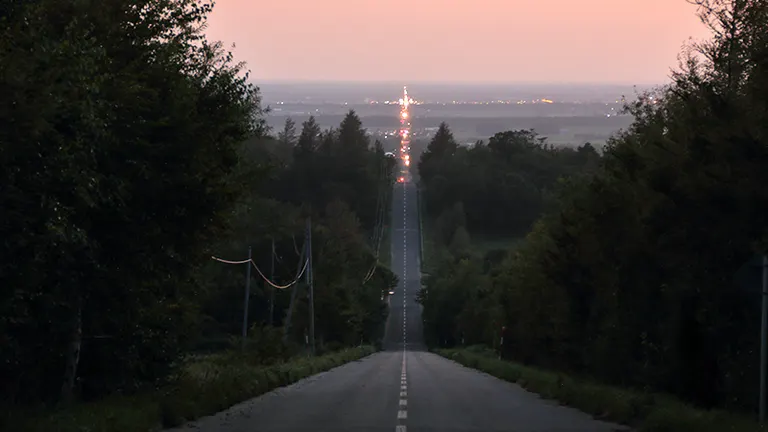
12. The Road to Heaven: Be Moved by a Road Stretching to the Far Horizon!
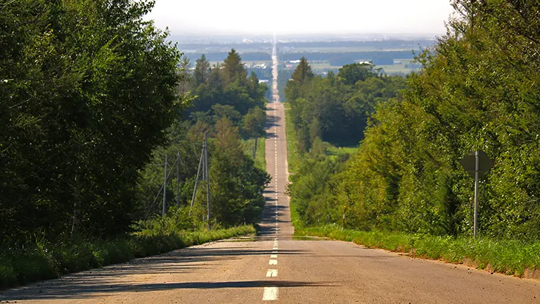
This scenic road gets its name from the way the endlessly straight path appears to connect directly to the sky. If you want to experience the dramatic moment when the road suddenly appears before you, we recommend taking National Route 334 from the Utoro area towards Shari and turning left at Minehama. If you time your visit around the spring or autumn equinox, you might witness the sun setting right at the end of the road—a truly moving moment that perfectly embodies the name 'Road to Heaven.'
Road to Heaven
■Reference Distance (without using toll roads)
・Tomakomai East Port to the Road to Heaven: Approx. 387 km
・Shari Town to the Road to Heaven: Approx. 11 km
See more details about the "Road to Heaven" on Domingo
13. The Niseko Panorama Line: Enjoy the Four Seasons of Nature's Grandeur
The section of Hokkaido Route 66 connecting Niseko and Iwanai is known as the 'Niseko Panorama Line.' It's a popular winding road, chosen as one of the '100 Famous Roads of Japan' for its continuous dynamic scenery. In addition to magnificent views of Mt. Yotei and the Niseko mountain range, you can also see the Sea of Japan. Driving through this grand landscape is exhilarating! It's also a great idea to take a break and stroll around the nearby Shinsennuma Marsh. While summer, with its lush greenery, is wonderful, autumn is the most recommended season, when you can drive through a landscape that seems to be enveloped in gold.
Niseko Panorama Line
■Reference Distance (without using toll roads)
・Tomakomai East Port to the Niseko Panorama Line: Approx. 129 km
・Niseko Town to the Niseko Panorama Line: Approx. 4 km
See more details about the "Niseko Panorama Line" on Domingo
14. Aikawa Viewpoint Parking: A 'Yama-ate' Road with a View of Mt. Yotei
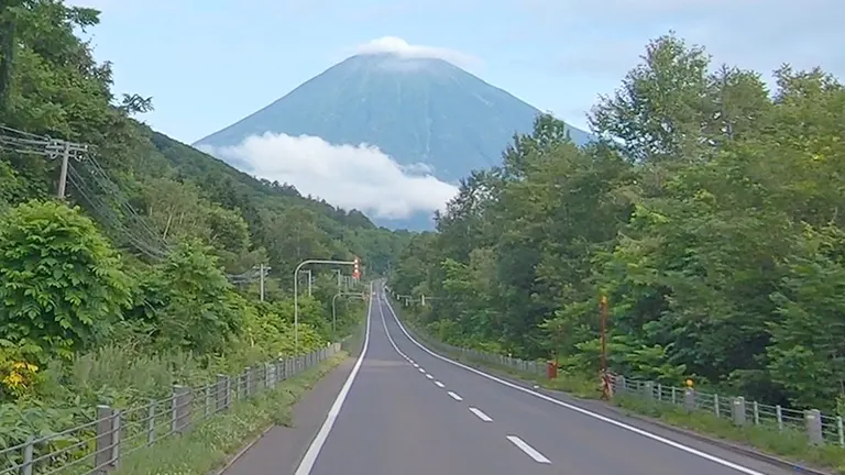
A 'Yama-ate Road' is a road design technique where a straight road is aligned to point directly at a mountain. In Hokkaido, the 'Yama-ate' view of Mt. Yotei that appears as you travel along National Route 276 from Kimobetsu is exceptionally beautiful and dynamic! The 'Aikawa Viewpoint Parking' is located along this highway, allowing you to take a break from driving and fully appreciate the scenery. You'll be overwhelmed by the sight of Mt. Yotei, affectionately known as 'Ezo Fuji' for its resemblance to Mt. Fuji, as it seems to grow larger and closer the further you drive.
Aikawa Viewpoint Parking
■Reference Distance (without using toll roads)
・Tomakomai East Port to Aikawa Viewpoint Parking: Approx. 102 km
・Kimobetsu Town to Aikawa Viewpoint Parking: Approx. 2.5 km
See more details about "Aikawa Viewpoint Parking" on Domingo
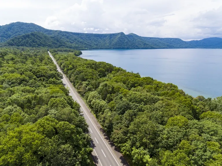
15. Lake Shikotsu Sky Road: A Stretch of Blue Beyond the Deep Green Forest
Hokkaido Route 16, leading from Chitose City to Lake Shikotsu, is called the 'Lake Shikotsu Sky Road.' It's a straight road that cuts through a beautiful forest of larch and white birch trees. As you drive through the deep green, feeling the refreshing breath of the forest, you'll be greeted by Lake Shikotsu, which boasts some of the clearest water in Japan. You're sure to be captivated by the mystical blue glow known as 'Shikotsu Blue.'
Lake Shikotsu Sky Road
■Reference Distance (without using toll roads)
・Tomakomai East Port to Lake Shikotsu (via Route 16): Approx. 70 km
・Chitose City to Lake Shikotsu (via Route 16): Approx. 36 km
See more details about the "Lake Shikotsu Sky Road" on Domingo
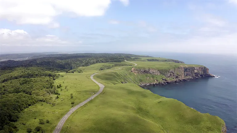
16. Shakotan Peninsula Blue Line: Tour Scenic Spots Along a Beautiful Coastal Route
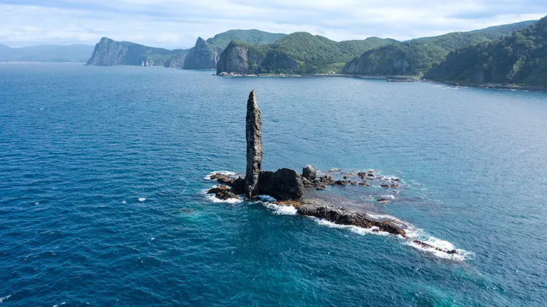
The 'Nihonkai Oiwake Soran Line' connects Hakodate and Otaru on the Sea of Japan coast. The section of this route between Yoichi and Iwanai is nicknamed the 'Shakotan Peninsula Blue Line' for its beautiful scenery. The stretch from Yoichi to Shakotan is called the 'Setakamui Line,' and the part from Shakotan to Iwanai is the 'Kabuto Line.' The 'Shakotan Peninsula Blue Line' is the collective name for both routes. This route along the Shakotan Peninsula coastline will delight your eyes with the beautiful 'Shakotan Blue' sea, as well as dynamic scenery featuring unique rock formations like Candle Rock and dramatic cliffs. There are many scenic spots like Cape Kamui, Cape Ogon, and the Shimamui Coast, so stopping by along the way is highly recommended. And don't forget to taste the local specialty, fresh sea urchin!
Shakotan Peninsula Blue Line
■Reference Distance (without using toll roads)
・Tomakomai East Port to Yoichi Town: Approx. 155 km
・Yoichi Town to Cape Kamui: Approx. 48 km
See more details about "Cape Kamui" on Domingo
17. Akan Crossing Road: Experience Magnificent Nature
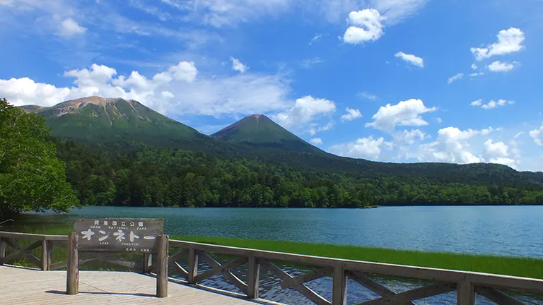
This is a main tourist route in eastern Hokkaido, connecting Ashoro and Teshikaga from east to west, featuring a succession of peaceful farm landscapes and exhilarating forest roads. Along the route, you can enjoy sights such as Lake Akan, famous as a habitat for marimo moss balls; the mystical Lake Onneto, which shows various expressions depending on the season and weather; and the magnificent views of Mt. Meakan and Mt. Oakan. This route is also home to a lot of wildlife, so please drive with caution.
Akan Crossing Road
■Reference Distance (without using toll roads)
・Tomakomai East Port to Lake Akan: Approx. 278 km
・Ashoro Town to Teshikaga Town: Approx. 94 km
See more details about the "Akan Crossing Road" on Domingo
*All information provided is current as of May 2025.
*Please note that information may change. Check official websites for the latest details.